Nchumburu, Kyombaron in Ghana

The Nchumburu, Kyombaron have only been reported in Ghana
Population
Main Language
Largest Religion
Christian
Evangelical
Progress
Progress Gauge

Introduction / History

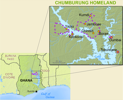
The Chumburung live on either side of the River Volta, west, north, and east of Kete Krachi. They were divided by the waters of the Volta Lake into five isolated districts. The area covered by these five districts is about 2,200 square kilometres. They are mainly farmers with their farms located within a few kilometers of the villages. The crops that they grow are yams, cassava, beans and corn.

The Chumburung are thought to have been located in the present area before 1700. The Gonjas say they were part of the invading army of Ndewura Jakpa. The British subjected the Chumburung to the Gonja chief of Salsga, and when they tried to assert their independence in the early 1930s the Gonja raided a number of Chumburung villages, causing many to flee to the present Volta region. The original colonial boundaries still divide the Chumburung today, and the lake Volta has broken up this people even more dramatically.

There is significant Christian presence in the area with Catholics, The Evangelical Church of Ghana, The Evangelical Presbyterian Church, Church of Pentecost and Seventh Day Adventists all represented. There are hardly any Muslim Chumburung, though in many towns there are communities of Muslim traders who have their own mosques.


Prayer Points

Scripture Prayers for the Nchumburu, Kyombaron in Ghana.


Profile Source:   Anonymous  

People Name General Nchumburu
People Name in Country Nchumburu, Kyombaron
Alternate Names Chumburung; Kyombaron
Population this Country 112,000
Population all Countries 112,000
Total Countries 1
Indigenous Yes
Progress Scale 4
Unreached No
Frontier People Group No
GSEC 1  (per PeopleGroups.org)
Pioneer Workers Needed
People ID 13266
ROP3 Code 107144
ROP25 Code 305938
ROP25 Name Nchumburu
Country Ghana
Region Africa, West and Central
Continent Africa
10/40 Window No
National Bible Society Website
Persecution Rank Not ranked
Location in Country Northern region: East Gonja district; Brong-Ahafo region: Sene district; Volta region: Krachi district; triangular area with Volta lake south, Daka river northwest, Yeji is south of the lake.   Source:  Ethnologue 2016
Country Ghana
Region Africa, West and Central
Continent Africa
10/40 Window No
National Bible Society Website
Persecution Rank Not ranked
Location in Country Northern region: East Gonja district; Brong-Ahafo region: Sene district; Volta region: Krachi district; triangular area with Volta lake south, Daka river northwest, Yeji is south of the lake..   Source:  Ethnologue 2016
Primary Religion: Ethnic Religions
Major Religion Percent
Buddhism
0.00 %
Christianity  (Evangelical 3.00 %)
45.00 %
Ethnic Religions
55.00 %
Hinduism
0.00 %
Islam
0.00 %
Non-Religious
0.00 %
Other / Small
0.00 %
Unknown
0.00 %
Primary Language Chumburung
Language Code ncu   Ethnologue Listing
Language Written Yes   ScriptSource Listing
Total Languages 1
Primary Language Chumburung
Language Code ncu   Ethnologue Listing
Total Languages 1
People Groups Speaking Chumburung
Map Source Anonymous  
Profile Source Anonymous 
Data Sources Data is compiled from various sources. Learn more.


Joshua Project logo    Joshua Project    Copyright © 2024